Friday 31 May 2013

Boot Sales

26 May 2013

Yard sale, flea market, garage sale, moving sale, rummage sale, tag sale, white elephant sale. All are synonyms for basically reselling treasures, valuables, stuff or junk to someone who is willing to part with their small change or bills.

In England they call them boot sales, or jumbles. And typically they seem to be on Sundays.

Suzanne and I chose to visit the two big ones in Cumbria; the nice one in Cockermouth is held in an auction barn for farm animals, the stalls being converted for selling stuff instead of holding a sheep or three. The other one was in a riding facility--it appeared to be a race course!


Why "boot sale"?  The concept is that a family loads up their car truck, or boot as its called here, and goes to the designated spot and opens their boot!

We found a few nice things. I got some very fine fly tying line for model airplane radio antennas and a couple of walking sticks plus a nice desk lamp perfect for modeling. Suzanne found a nice figurine of a Jack Russell Terrier and some cups and saucers plus a few prints of pansies.

All very nice and we spent nearly nothing but had lots of fun. It was fun trying to understand the locals as we dickered, you know we don't sound like we come from around here, or "you came a long way!" was heard a lot.

Until next time...


Thursday 23 May 2013

Eskdale Moor

19 May 2013


The weather guesser got Saturday right: rain all day, sometimes heavy. So I did what any smart American would do...I went for a fell walk...on Sunday.

Earlier in the week I did my planning, looking for something different but challenging. The description of Eskdale Moor was of a pleasant hike up in the moors, a bit of scenery to look at and all in the shadow of Scafell Pike. At about 3 miles each way and only a little elevation, it sounded the trick. 

Unlike Saturday, the weather guessers got Sunday wrong. The forecast was mostly sunny and warm, after a partly sunny start in the morning. So I decided my hike would start at 10 am and I'd enjoy the best parts of the day...not so with the weather.

Instead it was overcast, all day.

"Warm" may be in the 50's to some folks, but when I hear warm I think high 70's. So it was really a cool day and what warmed me was the hike.

Eskdale Moor rises in the middle of a valley southwest of Scafell Pike, and south of Whin Rigg. My place in Gosforth is in the valley north of Whin Rigg. I could have walked to the trail head, but at 3.5 miles it would have added a full 7 to an already long walk. I'm not ready for that...

The trail head is in Eskdale Green, a little village with more pubs than houses, it seems. It's a popular camping spot, and even has an elementary school.


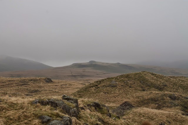
The photo above is looking towards Scafell (can you see it in the distant fog?) from the school parking lot. Turns out the 1.5 miles I walked to the trail head I could have avoided, there's a parking area their as well.


In the above photo it's just out of frame to the left. This is a junction point, I can either take a boring hike across that bridge and then bear right, or make a hard right from where I'm standing and make an interesting hike up into the moors. Guess what I chose?

But first, a greeter met me at the first fell gate: a ewe with her lamb. It always makes smile how I seem to surprise them, like I popped out of nowhere.


So I turns right and pass through (actually stepped over) a logging trail gate and headed up the fell towards the moors.


The forest is real quiet as there aren't many bird noises and occasionally I could hear a cow mooing or a sheep bleating. But mostly just the crunch of my shoes on the gravel as I trudged up. There were a few flowers, but nothing that pulled me to take a picture. I did see this small brook that compelled me.


I emerged from the woods and was greeted by both a pretty and ghastly site. On one hand the valley was quite beautiful in the mist, but on the other was the scars left from farming the trees. A necessary evil...

From this point was the most difficult part of the hike. I had to leave the road and turn right to go up. Ten minutes of steep climbing up to the moors.

Once at the top the panorama is quite flat. I followed the trail off to my left until I found the first of the tarns (ponds). Okay, this looks more like a marsh, and basically that is what a tarn is, a marshy area that could also be a shallow pond.

Interestingly, it was so wet that the ground on the moors ranged from thick bog you could easily walk on to the marshy tarn above. My feet stayed dry but my pant legs were wet.


This is Blea Tarn, I skirted around its south edge, to the right there. Then up through that low pass on the right.


This was the view south after I passed over the ridge.


In the distance was my objective: Boat How. It's a rock outcrop that from this vantage looks like a Viking boat laid upside down. Off I trudged as it's a good 1-2 miles away!


As I walked I could hear a cascading water sound, but until I got this view off to my right (south) I wasn't sure where it was. It was quite loud, and that's got to be three miles or so to the opposite moor leading up to The Pike and Hesk Fell.


This the shot of the real treat: two sets of stone circles from ancient times. One on each side of that rock outcrop. They were each about 100 feet in diameter, the stones big enough to need a large truck to carry them. One theory is that it was a meeting place for tribal chiefs, each stone representing the area behind the chief that he controlled.


The view from Boat How. This is looking west towards the Irish Sea, that valley is the boring route up (and the route I took back). Hard to tell, but those trees in the center, to the left of the farm, are the ones I merged from and clambered up to the fell.


Finally, this is Burnmoor Tarn, looking east towards Scafell, which is that very high peak just behind it...don't see it? It's the one in the thick fog!


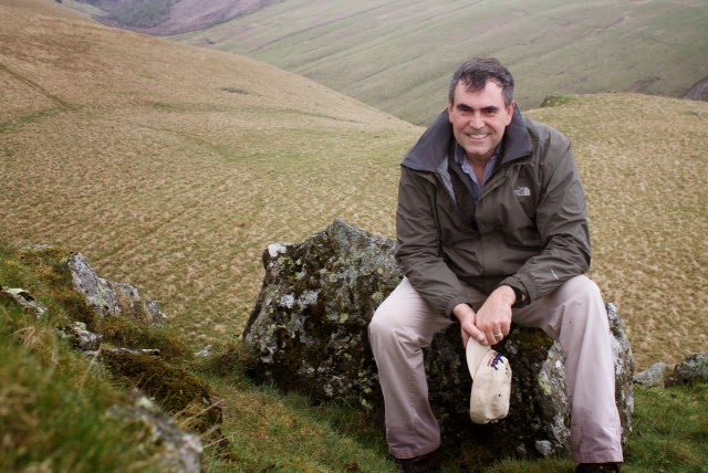
Here is one of my failed attempts at getting a self picture at the top.

Eskdale Moor to Boat How via two stone circles. 8.2 miles, 385 meter ascent, 4 hours.


Until next time...


Sunday 12 May 2013

Seascale

12 May 2013

The forecast for this weekend was poor.  Cold, windy, rain on Saturday and with only some opportunity for dry weather on Sunday morning.  So out I went this morning and looking up at the fells they were surrounded in fog/clouds, which is 1) not safe when it's cold, and 2) usually wet.  This is actually looking over at the fells.
So I again decided to stay low and flat for my hike.  Seascale is on the Irish Sea, about 3 miles from Gosforth.

The walk was okay, I won't do this route again simply because the traffic was too much even for a Sunday morning.  Remember, the roads are narrow and speed limits are 60!  I had to step off every few yards to allow cars to pass.

As I entered Seascale the sea breeze brought a great smell.  Something about the smell of the sea...


By the time I got to the beach, it began to sprinkle; a warning of what was to come. I did snap these pictures and watched the dogs enjoy themselves. The tide was out so I walked down to a couple of pools. Not much there but these long shells. I've never seen anything like these, but my guess is tube worms.


Since it was getting wet I put my camera away and started walking back. As I left Seascale the smell of the land returned. Now I know why, even when there is a strong breeze from the beach, why it still smells like the land just 3 miles in: the sheep and cattle! I had grown accustomed to their smell but as I walked back from the beach and their smell overcame the smell of the sea it's obvious why up in Gosforth it's like being in the middle of Iowa (smell wise anyway). I did pull out my waterproof camera (not very good quality) and shot this view of Buckbarrow as I returned.


 Until next time...


Monday 6 May 2013

Crag Fell

This morning begin with some rain, then overcast and generally damp until about 1pm -- typical English weather.  The forecast was for sunny and warm (70's) by 4pm, so I headed up to Ennerdale Water and started my hike at 4pm sharp.  The weather guessers got it right!

Ennerdale is about 30 minutes away (10 miles as the crow flies) because the most direct route is via a fell road from Calder Bridge to Ennerdale Bridge.  30 mph is a safe speed as you dodge sheep and other cars along winding lanes that are only about 8 feet wide.  Every 100 meters or so is a passing area, which is to say the road widens to 2 lanes for about the length of a car!  Okay, the idea is you pull over and let the oncoming car get by.  The drive alone was worth the trip, it is beautiful and when Suzanne is here I'll take her through to see the lambs and take some pictures.

There are actually fell trails up there for walking...I may have to investigate them some Saturday...

I chose Crag Fell because it isn't a high fell (523 meters), it's close, and the trails to the top appear gentle enough for me to tackle while I build my stamina.  Unfortunately I chose the wrong trail...

That's Crag Fell.  You can see a couple of the trails on the lower left of the fell, plus there is one that goes through the woods just to right of center.  That's the route I took.

Ennerdale Water is at 110 meters.  It's not a large lake, and there are trails that lead all the way around it.  There were quite a few folks walking around the lake.

At this point, I wasn't sure which trail was which, my guidebook basically says to walk along the lake, pass through a gate and turn right (for trail number 2) and follow a stone fence until you get to an opening in the woods.  Then follow the switchbacks up the fell until you can ford the stream towards the left.  From there (per the guidebook) it's an easy hike up the fell along a ridge past Revelin Crag and Cragfell Pinnacles.  

So find the stone fence and follow it to the wooded area.  Then look up at the trail…

Hmm, somethings wrong here!  There's not much of a trail, and I don't see any switchbacks.  Ah, there they are along the fence to the right.  Not so much switchbacks as steps people have created as they walked up.  Oh well, up I go.  It's not that high, so how hard can it be?

Well, it was freaking very hard!

After about 50 meters up I was huffing and puffing.  Then it got steeper…and steeper…and steeper.  I was going up more than going forward.

Occasionally I'd turn around (and nearly fall over it was so steep!)  But I had to stop and take this shot.  As Ann says, these are European Larch trees.  A hardwood conifer that is deciduous.  I always thought deciduous trees were evergreens, as I thought conifers were evergreen.  But these lose their needs in the fall.

After a while (okay 30 minutes of hard climbing) it got less steep (certainly NOT flat) and as I rounded this outcrop I decided to take this picture.

As the guidebook says, I crossed the stream, below it was pretty wide and with lots of water, up here it was about a foot wide!  The trees were now below me and I looked up and could see Crag Fell directly.


At this point I'm about 45 minutes up, and the earlier part of the climb had killed my legs.  So every 25 meters or so I stop to catch my breath.  Up and up I go; from here it's about 200 meters vertically more to the top.


What a great view!  This is looking east towards the upper end of the lake.


Gratuitous shot of me at the top.  


After 30 minutes of rest, some hot tea, water (of course) an apple and some trail mix I was ready to head back down.  I decided to take a different route down (trail number 3 I'd hoped, but it was not to be).  I came by Cragfell Pinnacles and took this shot, it feels as though I'm looking straight down.  There is actually a trail down to the Pinnacles but I wasn't sure where the trail led from there…and I did NOT want to have to climb back up to this one!


As I came down, this just looked like a Kodak moment.  You can see the trail coming from the lower right.


Another pretty shot looking back up the fell.


And another…


And finally, over to where my car is, off to the left, just before that building.  If you can spot it…the weir (falls) from the top photo above is in the lower center of the picture.


Crag Fell.  4 miles.  413 meters up from the lake level.  3 hours.

Until next time...


Saturday 4 May 2013

On The Road

More adventures on the road this weekend. I decided to drive down south to Barrow...only 40 miles away. Remember that number.

Knowing the roads south of me are a bit more narrow and a bit more winding, I headed out with my trust GPS looking for what I may find. Okay, I am still looking for a good hobby/toy/craft shop where I can buy paints, glue and what not. 

Barrow is known for two things: 1) it's a shipping port so lots of big ships, cranes and loading docks; and 2) Furness Abbey. 

Furness Abbey is famous for being the last Catholic Abbey to be sacked and destroyed by King Henry VIII when he decided he no longer wanted to be second to the Pope and answering to him. His soldiers could not find the Abbey and as they left in despair thinking they would surely be called to account for their failure, the monks (thinking they'd been spared by God) let the church bells ring in celebration...cue a soldier cocking his ear...they followed the sounds of the bells until they found the Abbey. The rest they say is history. 

I was almost in as much despair when as I approached Barrow I was greeted by a sign saying "road closed". Hmm, no detour signs, no obvious way around, and the lane is not blocked...I'll keep going. A few miles later, another sign, same message and same concerns. I keep going. Within about 2 miles of the town, as I crest a hill overlooking the town...yes, the road is blocked. 

I fiddled with my GPS for about 20 minutes until I found a route that would take me around the roadblock and it's only about 4-5 miles out of my way...

Only half a mile back whence I'd come, I turned up a road that quickly got very, very narrow. There was about 6 inches on each side from my mirrors and the stone walls went right up to the top of the car. Only 2 miles...I can do it, at least it's paved. I pass one farm and the stone fences changed to hedge rows. But now they are 10 feet tall and narrowed so that my mirrors and occasionally the doors get whacked by hedge branches. And it's now very steep. I'm in first gear and the car is working very hard to make it up the hill (road is still paved by the by) and there is zero room to do anything but go forward. 

If I'd come across somebody going in the opposite direction, we'd have been in a real pickle. I was NOT going to back up!

While the car strained to climb my knuckles were white trying to keep the car on the road. Oh, it's got that "humped" shape to it, the center was so high I was worried the oil pan would scrape if there was a pothole or something.  Up and up I went along that road, all the way up the hill. It had started snowing...really!?  Snow!?  My ears popped I'd gone so far up that damn hill. 

Suddenly I rounded a corner and the hedge row stopped. I was about 50 feet from the end of the road, nearing a T where the GPS told me to turn right. No more trees, no more hedge rows. But two sheep who were looking at me wondering what some human was doing all the way up here. 

I turned right an the road was wider. Still paved and obviously like a farm road, but with the snow I was a bit concerned. I kept going. I was now going back down the hill, but on the other side. 

After a couple of miles the hedge rows returned as did the stone fences. I saw another car and the some houses. The city was visible again, albeit from a different angle. Instead of approaching the city from the north, I was now coming in from the east (south or west would have been from the ocean). Another mile and I was in the city. 

3 hours later...........40 miles. 

So I found the hobby shop and it was a mess. Old school hobby shop with stuff everywhere. The owner asked if I needed help, when I spoke he noted I wasn't from around here. I says, "No, I'm from up north."  The other gent in the shop then said something only a local could understand, but I did make out the word "sheep". When the owner chided him for saying "those kinds of words" I realized I'd just been insulted. Well, he ain't gettin' a nickel out of me!  So I left after just 5 minutes. 

Back up north I went but this time I took the eastern route that looped around the north of the county, and then drove back south to home. Amazingly it only took me an hour and 15 to get home...I won't make that trip again. 

Here's a couple of photos along the way. I wonder how old a stone fence has to be to get that much moss?


Thursday 2 May 2013

Wastwater

27 April 2013

The forecast was for a cold start to the day with possible frost, and very windy.  Later in the day, although the temperature would rise a bit, it was supposed to begin raining.  So I chose to take it a bit easy and keep the walk at a lower elevation but at the same time see how far I could go in 4 hours.  I decided to head up Wasdale Road from Gosforth and at the 2 hour point turn around and head back.  I would start at 10am to ensure it wasn't too cold and be back before the rains.


Wasdale Road goes east from Gosforth towards Wasdale Head via Nether Wasdale and by Wastwater, the deepest lake in England.  The road pass south of Buckbarrow, the fell I walked up the Saturday before.  In the picture above, Buckbarrow is to the left of center, the near promontory.  Today's walk would route me in a round-about way past Buckbarrow in that valley in the middle.

Shortly after my walk started, about 30 minutes in, true to Cumbria the weather changed and it started raining.  While it was only a light rain, I was glad I'd gotten a proper hiking jacket.  This one is light, but both wind resistant and a (light) rain coat.  It turned out to be perfect.  Gosforth itself is at about 67 meters elevation, and while the road is more an undulating farm road, not steep but not flat, there are two rather steep inclines.  Both are about 14 degrees grade, the first is about 45 minutes from the house and peaks at 95 meters, the second is about an hour later and peaks at 124 meters.  Of course, the height is not the "problem", it's the grade!  That first one makes for a good evening walk as it really gets the heart pumping.

I kept up a good pace for my walk, I think all that marching so many years ago gave me a natural cadence.  I rounded a corner and between the trees I got this view of Buckbarrow.  Yeah, the week before I was up there!


A bit further along I got to the fell gate.  That's the point that the fell technically begins, above the tree line and it's considered a common area for grazing.  The cattle grate is a good indicator of "where" the fell gate is located.  Buckbarrow is the near peak on the left, and in the distance is Sca Fell.

A hundred yards or so along the road, I passed some sheep.


They were a bit concerned with the two sheep behind me as I took the picture.  I had inadvertently split up the small herd as I walked.  I moved to the left of the road when the fence gave them enough room and the two rejoined their friends.  All was right with them at that point.  


The above picture is Illgill Head.  It is on the other side of Wastwater, which is not very far away at this point.  This was at the 2 hour spot, but I knew I was close to the lake so decided to keep going.  Illgill is a future hike…

Wastwater, my destination.  This picture is looking toward the north east, Sca Fell is the highest peak in England and is just to the right and out of sight behind Illgill.  I sat and enjoyed some hot tea I'd brought in a thermos; yes it was cold!  The winds off that very cold lake made the wind chill near freezing.  I also had some snacks and reloaded on some energy for the walk back home.  Elevation is 65 meters, about the same as Gosforth.


Finally, this is Buckbarrow looking back from where I came.  To the right there is actually a trail that most hikers use; it starts from Wasdale Head, about 3 miles further up the road and the other end of the lake.  It's also the trail head for Sca Fell, and some of the other Fells in the area.

I had my Garmin foreTrex 401 GPS with me, it's a hand held that Suzanne got me for Christmas a couple of years ago.  I've always used it for sailing, but it's also useful for hiking and actually has some features that support that, like recording elevation as well as my track.  Once I figure out how to display the route on a real map (I don't want to buy the $60 mapping software, yet) I'll be able to upload a map of my route.  

Total distance was 11.4 miles, maximum elevation was 122 meters and my total time was right at 4 hours (a bit quicker coming down the hill!).  

Until next time…