The forecast was for a cold start to the day with possible frost, and very windy. Later in the day, although the temperature would rise a bit, it was supposed to begin raining. So I chose to take it a bit easy and keep the walk at a lower elevation but at the same time see how far I could go in 4 hours. I decided to head up Wasdale Road from Gosforth and at the 2 hour point turn around and head back. I would start at 10am to ensure it wasn't too cold and be back before the rains.
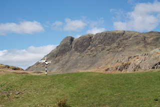
Wasdale Road goes east from Gosforth towards Wasdale Head via Nether Wasdale and by Wastwater, the deepest lake in England. The road pass south of Buckbarrow, the fell I walked up the Saturday before. In the picture above, Buckbarrow is to the left of center, the near promontory. Today's walk would route me in a round-about way past Buckbarrow in that valley in the middle.
Shortly after my walk started, about 30 minutes in, true to Cumbria the weather changed and it started raining. While it was only a light rain, I was glad I'd gotten a proper hiking jacket. This one is light, but both wind resistant and a (light) rain coat. It turned out to be perfect. Gosforth itself is at about 67 meters elevation, and while the road is more an undulating farm road, not steep but not flat, there are two rather steep inclines. Both are about 14 degrees grade, the first is about 45 minutes from the house and peaks at 95 meters, the second is about an hour later and peaks at 124 meters. Of course, the height is not the "problem", it's the grade! That first one makes for a good evening walk as it really gets the heart pumping.
I kept up a good pace for my walk, I think all that marching so many years ago gave me a natural cadence. I rounded a corner and between the trees I got this view of Buckbarrow. Yeah, the week before I was up there!
A bit further along I got to the fell gate. That's the point that the fell technically begins, above the tree line and it's considered a common area for grazing. The cattle grate is a good indicator of "where" the fell gate is located. Buckbarrow is the near peak on the left, and in the distance is Sca Fell.
A hundred yards or so along the road, I passed some sheep.
They were a bit concerned with the two sheep behind me as I took the picture. I had inadvertently split up the small herd as I walked. I moved to the left of the road when the fence gave them enough room and the two rejoined their friends. All was right with them at that point.
The above picture is Illgill Head. It is on the other side of Wastwater, which is not very far away at this point. This was at the 2 hour spot, but I knew I was close to the lake so decided to keep going. Illgill is a future hike…
Wastwater, my destination. This picture is looking toward the north east, Sca Fell is the highest peak in England and is just to the right and out of sight behind Illgill. I sat and enjoyed some hot tea I'd brought in a thermos; yes it was cold! The winds off that very cold lake made the wind chill near freezing. I also had some snacks and reloaded on some energy for the walk back home. Elevation is 65 meters, about the same as Gosforth.
Finally, this is Buckbarrow looking back from where I came. To the right there is actually a trail that most hikers use; it starts from Wasdale Head, about 3 miles further up the road and the other end of the lake. It's also the trail head for Sca Fell, and some of the other Fells in the area.
I had my Garmin foreTrex 401 GPS with me, it's a hand held that Suzanne got me for Christmas a couple of years ago. I've always used it for sailing, but it's also useful for hiking and actually has some features that support that, like recording elevation as well as my track. Once I figure out how to display the route on a real map (I don't want to buy the $60 mapping software, yet) I'll be able to upload a map of my route.
Total distance was 11.4 miles, maximum elevation was 122 meters and my total time was right at 4 hours (a bit quicker coming down the hill!).
Until next time…


No comments:
Post a Comment